 Summary of the Submission by the
Australian Speleological Federation (Inc) to the
Department of Environmental Protection
regarding the Clearing of Land
on Victoria Location 10598
Cockleshell Gully Road, Jurien (880)
The Federation proposes that the Environmental Protection Authority recommends that a comprehensive study of the hydrology of this area is undertaken prior to any land clearing.
The Federation recommends that further investigation be undertaken of the aquatic fauna of Old River Cave prior to any land clearance.
Submission by the
Australian Speleological Federation (Inc)
on the Clearing of Land
on Victoria Location 10598
Cockleshell Gully Road, Jurien (880)
INTRODUCTION WHAT IS THE ASF?
The Australian Speleological Federation (Inc) (ASF) comprises 27 corporate caving clubs and 20 associate caving clubs distributed throughout Australia. It is directed by a council headed by an executive. As well, the Federation has a number of Commissions that oversee Federation activities between meetings of the council and the executive.
The Conservation Commission of the ASF has four Co-Convenors who are strategically located across Australia to liaise with government departments, private land owners, or companies involved with the management of cave and karst resources.
The ASF has provided consulting services relating to cave and karst management to public and private cave managers throughout Australia. They have also assisted many cave managers in the identification of the cave resources with the karst of their reserve, National Park or private land holding. This involves activities such as surveying caves, tagging cave entrances, performing inventories of features and cave life within the cave.
The Federation has also been involved with four of Australia's most important karst conservation issues. The Mt Enta limestone mine in Queensland (for over 10 years), the Yessabah limestone mine in New South Wales (Keir Vaughn-Taylor 1991), the Lune River Quarry in Tasmania and the Sellicks Hill Quarry Cave (Buswell 1994) blasting and subsequent inquiry. In three of these cases mining has halted at each site and significant attempts have been made to preform restoration (Gillieson 1995) to parts of the quarries. In the case of Sellicks Hill mining of the cave has been halted while the inquiry has been in progress.
MANAGEMENT OF KARST AREAS
Karst is a word that is used by geomorphologists to describe an area or region that comprises a soluble rock type such as limestone. From a management perspective the plan of management for a karst area should integrate all of the management objectives towards the conservation of the karst region. Many of the features with a karst region are highly visible such as pinnacles, dolines or caves. However it is the integrated management of the karst area that protects all of the karst features.
MAJOR POTENTIAL ENVIRONMENTAL IMPACTS
The major environmental concerns of the Federation are:-
- The unknown effects of the clearing on the hydrology of Old River Cave.
- The unknown effects on the aquatic cave fauna of Old River Cave
It is anticipated that the clearing of 873ha of land will have a MAJOR impact on the ground water table. The Federation considers that this impact is likely to have a considerable effect on all of the cave systems developed at the water table. At present only Old River Cave (a 2km long cave system) is known to contain an active stream passage. However it is likely that considerably more cave is present but not accessable to humans.
HYDROLOGY
During 1995 a number of eminent Australia karst management experts and speleologists drafted a set of guidelines for Cave and Karst Protection for the IUCN (Gillieson et al 1995). This set of guidelines highlights the sensitivity of karst regions and their need for specialised management.
Some of the guidelines relating to the hydrology of karst systems from the IUCN draft are enunciated here (within italicised boxes - followed by guidelines) to emphasise what the Federation considers are aspects of the CER that have not been adequately addressed.
Caves and karst are amongst the most vulnerable of landforms, and are often subject to degradation as a result of phenomena or events which occur at a considerable distance. Their effective protection and management therefore requires consideration and action at both regional and local levels.
Guidelines
2. The integrity of any karst system depends upon an interactive relationship between land and water. Any interference with this relationship is likely to have undesirable impacts, and should be subjected to thorough environmental assessment.
3. Land managers should identify the total catchment area of any karst lands, and be sensitive to the potential impact of any activities within the catchment, even if not on the karst itself.
4. Destructive actions in karst, such as quarrying or dam construction, should be located so as to minimise conflict with other resource values.
5. Pollution of groundwater poses special problems in karst and should always be minimised.
6. All other human uses of karst areas should be planned to minimise undesirable impacts, and monitored in order to inform future decision-making.
These IUCN guidelines clearly indicate that the hydrology of karst regions are vital to their integrity. The catchment of the water that flows through Old River Cave cannot be delinieated. However it is clear due to the direction of the water flow in the cave (westerly) that the inflow for the system lies to the east of DCNP.
If the hydrology is examined to the east of DCNP the potential inflows of water to Old River Cave are indicated in Figure 1 as two elipsoids. The wetlands to the south of the proposed land clearance have been examined by Semeniuk & Semeniuk, 1994. These wetlands occur in Bassendean Dunes and are less likely to be related to the waters that are forming the cave systems (southern elipsoid). However they are significant wetlands as indicated by Semeniuk & Semeniuk 1994 and should be conserved. The northern water flow (northern elipsoid) is more likely to contribute to the karst waters. This water flow does not appear on the documentation in the CER but is obvious on the public map portion shown in Figure 1.
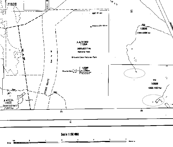
It flows through the area proposed for clearing and sinks in the southern block 10599, probably into a sandy inflow or soak. This water flow is likely to be the major inflow of water into the DCNP karst which has formed and continues to form Old River Cave and associated caves and karst features.
Land clearance of block 10598 is certain to allow greater quantities of water to enter the karst aquifers. A rise in water levels is likely to be significant with an unknown impact on the cave. The personal communication indicated in the CER is not sufficient documentation to ensure that the land clearance will not effect the cave systems of DCNP.
One example of research done on the impacts of altering surface conditions is given by Harmon (1977) who has shown that karst processes can be significantly modified by short term changes to plant/soil/water relationships. This reseach has admittedly been conducted a totally foreign karst however similar research is not available for the karsts of the South-West of Western Australia.
The Federation proposes that the Environmental Protection Authority recommends that a comprehensive study of the hydrology of this area is undertaken prior to any land clearing.
Cave Fauna
Only a small number of trips have investigated the cave life of Old River Cave. However an amphipod, Austro chiltonia sp., was collected from the stream in Old River Cave. This specimen was identified by Brenton Knott from the University of Western Australia who indicated that it differed from other specimens of this specied collected from Yanchep. The Old River Cave specimens had no eye spots indicating that they may have had more time to evolve that those at Yanchep that still have eye stalks.
The likely impact of the clearing on the cave amphipods is unkown but the alteration of their habitat WILL impact this aquatic species.
Cave adapted spiders of the family Linyphiidae have also been found in the entrance chamber of Old River Cave. These spiders are not common cave dwellers.
One of the major impacts on karst aquifers and aquatic cave fana are the clearance of native vegetation. The Federation stongly oposes the proposed clearing and draws the Environmental Protection Authorities attention to the draft IUCN guidlines on Cave and Karst Protection which emphasises the need to minimise the impacts of adjacent land managers with the following quotation:-
2. Encourage nearby land managers to minimise their impacts on the surface and groundwater quality and quantity.
The Federation recommends that further investigation be undertaken of the aquatic fauna of Old River Cave prior to any land clearance.
REFERENCES
Buswell. C. (1994) Sellicks Hill Quarry Cave. Australian Caver 136: 18-23.
Gillieson. D. (1995). Rehabilitation of the Lune River Quarry, Tasmanian Wilderness World Heritage Area, Australia. Australasian Cave and Karst Management Association Journal. 19: 4-10.
Gillieson, D, Hamilton-Smith, E. and Watson, J.R.. (1995). Draft Guidelines for Cave and Karst Protection, IUCN Commission on National Parks and Protected Areas, Australia.
Harmon, R.S. (1977). An isotopic study of ground water seepage in the central Kentucky karst. Water Resources Res. 15(2): 476-480.
Semeniuk, V. and Semeniuk, C. (1994). Ecological Assessment and Evaluation of Wetlands in the System 5 Region. A report to the Australian Heritage Commission, Canberra. ACT.
Vaughn-Taylor. K. (1991). What happened at Yessabah. Pp 108-113 in S. Brooks (ed.) Cave Leeuwin - Proceedings of the 18th Biennial Conference of the Australian Speleological Federation Inc., Margaret River, Western Australia. 30 December 1990 - 5 January 1991. Australian Speleological Federation, Broadway, New South Wales.