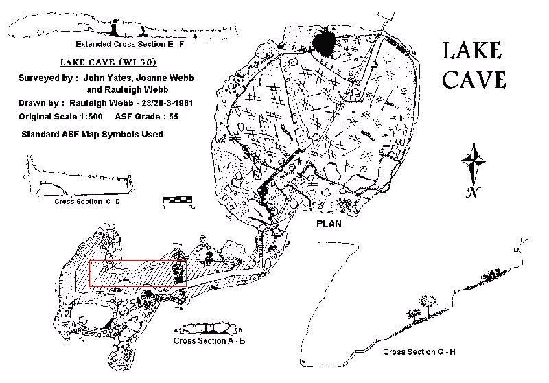
LAKE CAVE (Wi 30)
This article was published in:- The Western Caver, Volume 21 Numbers 2,3 & 4 Pages 34 & 35 in (1981/1982).
Location
Lake Cave is located thirteen kilometres SSE of Margaret River and three kilometres East of the SW coast of W.A. on the Leeuwin-Naturaliste Ridge. On ASF grouping of the cave features of the region, this cave is in the Witchcliffe Area and is specifically numbered as Wi 30. The locality is served by all weather roads from the North, South and East.
Form
From true ground level in the vicinity of the car park, a gentle slope leads to a spectacular doline entrance which contains it's own small forest of Karri (E. diversicolor) complete with typical understory. Leading under the Eastern edge of the doline floor a series of steeply sloping fissures lead down to the cavern floor. At this point a right angle turn is made and the total cavern extends 69m to the East. The cavern floor is covered in water of depths varying from 0.5m to 1.25m, and the flow of water from East to West has been calculated at 23,040 litres per hour (Webb 1979).
Geomorphology
Along with many other similar features in the coastal limestone (Eolian calcarenite. Lowry D 1965), the doline probably formed due to intense chemical weathering and physical corrasion of groundwater during a very wet era in the late Pleistocene. The evidence is that the entire ceiling of the original cavern literally 'fell in', as indicated by a clean exposed break around the major part of the surface perimeter of the doline. The progress of cavern development appears to have slowed somewhat since the collapse and the incursion of the stream under the N.E. wall of the doline can be traced by clearly defined sediment stratas, many of these lying some 20m above the present water table, some alongside the stream in the cave. Indications are that cavern development is still occurring although this is indefinite, as a guage to measure rotational collapse, (Henly 1962), was never followed up. Deposition of secondary calcites is quite spectacular and is continuing apace, particularly as stalagmites although owing to the majority of floor space being occupied by aggressive water, much of the floor decoration is restricted to stream banks.
Hydrology
The 'lake' of Lake Cave is actually the stream of water, which has formed the cavern system. It is the naturally regulated outflow of surplus winter precipitation from a surface area about 3km to the East of the cave system. Much of the region East of the limestone ridge is lightly capped with a pervious laterite, which allows much of the annual 125Omm of rainfall to soak through to the lower layers of granulites and granite gneiss (Horwitz and Gemuts. 1963), the natural relief of which is to the West. Thus the gently flowing streams feed under the limestone ridge and eventuate at the sea. Inflow into the Eastern end of Lake Cave is as a seepage around 180 degrees from the South to the North walls, rather than as a clearly defined stream. The reverse is true of the efflux point where at the Western end of the cavern, the pattern of flow can be quite clearly discerned as the water runs under loose rocks to leave the cave. Repeated attempts to define the resurgence of the water (dye trace ) at the coast can only be described as inconclusive. Despite greater than normal mineralisation, 48ppm CaC03: 36ppm MgCO3, the stream water is only mildly alkaline with a pH of 7.0 (Caffyn 1972). This relative acidity would account for the continued development which-is occurring within the cavern.
Historical
Although the doline entrance of the Lake Cave system was probably first reported by the early settlers as far back as 1896, it does not appear that any exploration was carried out for a number of years . It is known that one John Brockman had discovered the cavern during the 1890 Is and it was he who introduced the legendary Tim Connelly to the cave. Connelly was so taken by the beauty of the cavern that he named it "QUEEN OF THE EARTH" and proceeded, under the sponsorship of the State Parks and Gardens Board, to establish the walkways and conduct inspection tours for the public. It was probably the Government Surveyor, Marmaduke Terry, who introduced the less flowery name of Lake Cave. In the autumn of 1924, bushfire denuded the surrounding land and this was followed by torrential rains with heavy run-off into the doline. Extreme saturation of the doline floor caused rock and soil subsidence around the NW wall and this in turn blocked the stream passage almost directly beneath. Over the following three years, a veritable saga developed as Engineers and Workmen from the Mines Dept. and Public Works Dept. explored the drainage of the system and constructed tunnels and ducts to evacuate the water, banked up 1m deep in Lake Cave (Report on the Flooding of Lake Cave to State Hotels Dept.). Electric lighting was first employed during the late 1920's and the various replacement installations have led to the present system, which was commissioned in 1961.
Present
The popularity of the cave as a tourist venue is still maintained, with as annual throughput of 18 000 to 20 000 per year. Not with standing that 90% of the visitors attend during the summer and autumn period, the cave is open for inspection each day. Continual maintenance is required for the facilities such as tearooms, walkways, light system and car park. By far the more important task is the preservation of the surface environment above the cave, particular emphasis being placed on protective burning and removal of bush litter.
John Yates
References
Blatchford, T. (1924) Report of the Dept. of Mines. (reprinted in The Caver's Chronicle 8(2):2. (1980)
Caffyn, P. (1972) Water Analysis - Easter and Lake Cave. The Western Caver 12(2):38.
Henley, P. (1962). (Could not be located by Ed. thought to he in The Western Caver).
Horwitz, R.C. & Gemuts, 1. (1963) in Explanatory notes to the Augusta 1:250 000 Geological Sheet. Geological Survey of Western Australia, Perth.
Lowry, D.C. (1967) Explanatory notes to the Augusta 1:250 000 Geological Sheet. Geological Survey of Western Australia, Perth.
Webb, R. (1979) Determining flow rates in slow moving streams. The Western Caver 19 (2):34-37.
Editors Note
Many thanks to John Yates for writing the above Lake Cave article. John has been the head guide at Lake and Mammoth Caves for many years and so is by far the most qualified person to write about Lake Cave.
For those who have never visited Lake Cave - put it on your list of caves to visit and see a remarkable little cave.
Rauleigh Webb